AGRINEXO AGA Agroecology Geospatial Agent

AGRINEXO AGA is an agroecology geospatial agent, built to support farmers and technicians building more sustainable and resilient agroecosystems.
AGRINEXO .PT is an agroecology and operations management platform built on AGRINEXO AGA. AGRINEXO .PT is territorially scoped, with data sources and a knowledge base corpus specific to the Portuguese edaphoclimatic context and European Union Agricultural Policy.
When a user asks a question in AGRINEXO AGA AI Assistant, the LLM is offered a set of tools to get fields, crops and operations data, to make grounded answers possible, mitigating the risk of inadequate information. The AI assistant can draft operations and analyse crop images to propose technical observations on the state of the crop, weeds, pests and diseases.
AGRINEXO AGA Agroecology Geospatial Agent ranked #3 at the MunichTech EXPO Autumn Hackathon 2026.
Try AGRINEXO .PT [pre-release] (free 30 days trial).
About
AGRINEXO AGA is an agroecology geospatial agent, built to support farmers and technicians building more sustainable and resilient agroecosystems.
Agroecology is a multidisciplinary perspective encompassing main agroecosystems services: agricultural production, climate regulation, soil and water conservation, habitats maintenance and landscape preservation.
Agrifood systems account for about one-third of total anthropogenic greenhouse gas emissions. They are generated: within the farm gate (49%), from crop and livestock production activities; by land-use change (19%), caused by deforestation, biomass fires and peatland degradation processes often linked to land clearance for agriculture; and in pre- and post-production processes (32%), comprising the supply chain including food manufacturing, retail, household consumption and food disposal [1].
With the current technologies there a number of conflicting goals, that are extremely difficult to balance and conciliate. Soil is a major reservoir of carbon and while any loss of soil organic carbon content results in increased CO2 atmospheric concentrations, tillage is required to control weeds and prepare the land for crops. Over irrigation and the misuse of fertilizers and pesticides present a major risk to the quality and availability of freshwater, but any loss of primary productivity would require the further expansion of the land used for agriculture, with increased environmental impacts and an inherent loss in biodiversity [2].
Optimizing farming operations from an agroecological perspective, is a multi-objective endeavour that requires efficient land use and efficient energy use. The availability of relevant and accurate information increases the ability of individual farmers, technicians, land owners, and other relevant stakeholders, to make appropriate decisions.
Although we live in an era of unprecedented data availability, obtaining information that is relevant at farm level remains a major challenge. AGRINEXO AGA aims to combine AI reasoning with agroecology geospatial data to bridge the gap between scientific knowledge and the actionable information required for business decisions.
Features
Each field is delimited once, on the map. To add a new field, use the polygon drawing tool. Data collection (satellite imagery, climate and weather) runs asynchronously and takes a couple of minutes.
Crops are where the crop coefficients and the duration of each stage of the plant's growth cycle are defined. The AI assistant can propose typical values [3].
The Vegetation panel shows the evolution of NDVI and its spatial distribution, making it possible to identify anomalies before they become crop issues.
The Climate panel presents the climate normals for the last thirty years and for the previous thirty years, along with the anomalies observed. Understanding local climate change prevailing trends is essential to analyse and develop adaptation and mitigation measures.
The Water panel presents the soil water balance, to optimise irrigation management. In the Weather panel we can analyse weather variables over the previous days and a forecast for the next ten days.
Operations store the base information of field records. The AI assistant can draft operations and analyse crop images to propose technical observations on the state of the crop, weeds, pests and diseases.
Through WebMCP, AGRINEXO AGS tools are published to the browser agent itself. The browser agent may also bring context AGRINEXO AGA does not have as a checklist or a guideline, into the same conversation as your field data and it can also consult AGRINEXO AGA. Both agents share the same tools and the same view of your farm, and can work on a question together.
Data Sources and Design
AGRINEXO AGA delivers the geospatial user interface, a standard chat pane, API connectors and a set of AI orchestration interfaces that drive LLM reasoning, tool usage and WebMCP communication.
AGRINEXO AGS is an API service, that manages: fields, crops, satellite imagery, farm records and a knowledge base with semantic search. To optimize AI grounding,
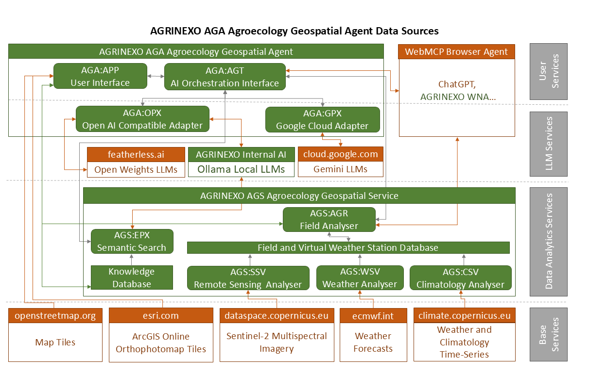
AGRINEXO AGS instances are to be territorially scoped, with data sources and a knowledge base corpus specific to the edaphoclimatic and socioeconomic contexts relevant for the intended end-users. Considering the intrinsic diversity of agroecosystems and the fundamental socioeconomic and ecologic value of this diversity, a generalized approach (although eventually feasible), risks degrading cultural traditions, economic resilience and biodiversity.
AGRINEXO .PT is an AGRINEXO AGA based platform operated by ETAPA RACIONAL. AGRINEXO .PT AGS instance is territorially scoped, with data sources and a knowledge base corpus specific to the Portuguese edaphoclimatic context and EU's Common Agricultural Policy. When a user asks a question in AGRINEXO AGA AI Assistant, the LLM is offered a set of tools to get fields, crops and operations data, to make grounded answers possible, mitigating the risk of inadequate information.
Large Language models can carry biases and converge on homogeneous approaches. AGRINEXO AGA AI Assistant can use several LLMs from different providers, so that users can compare answers from the diverse models available to check perspectives and obtain diverse alternatives.
References
[1] “Greenhouse gas emissions from agrifood systems. Global, regional and country trends, 2001–2023”, FAOSTAT Analytical Brief 115. FAO, Rome, Italy, 2025.
[2] V. Abreu and J. Abreu, "AGRINEXO AGM – Agri-environmental Monitor for Monday.com" (retrieved 2026-09-19). ETAPA RACIONAL, Lisboa, Portugal, 2022.
[3] R. Allen, L. Pereira, D. Raes, and M. Smith, “Crop evapotranspiration: Guidelines for computing crop water requirements,” U.N. Food & Agriculture Org., Rome, Italy, FAO Irrigation and Drainage Paper #56, 1998.
Pre-release features and specifications are likely to change. Only free 30 days trial subscriptions are available for applications in pre-release.